现代海洋探险 James Cook on the Endeavour,Resolution, and Adventure Charles Darwin on the Beagle James Clark Ross and John Ross on the Victory,the Isabella,and the Erebus Edmond Halley (trade-winds and monsoons) Benjamin Franklin (Gulf Stream) Knowledge from measurements ▣Wind system Temperature Currents Waves 口 Marine lives
q James Cook on the Endeavour, Resolution, and Adventure q Charles Darwin on the Beagle q James Clark Ross and John Ross on the Victory, the Isabella, and the Erebus q Edmond Halley (trade-winds and monsoons) q Benjamin Franklin (Gulf Stream) Knowledge from measurements q Wind system q Temperature q Currents q Waves q Marine lives
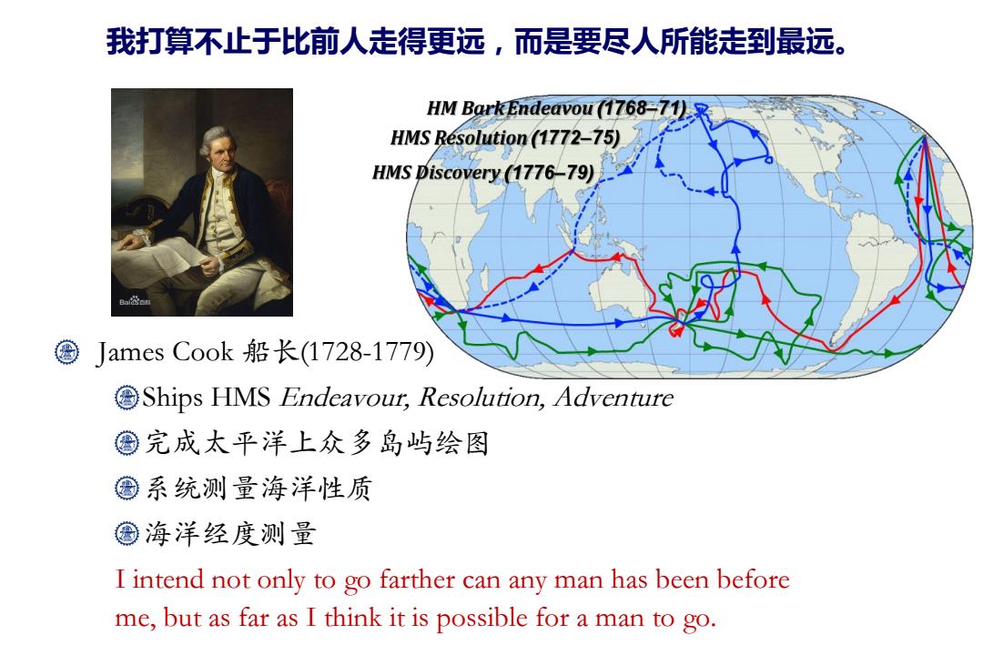
我打算不止于比前人走得更远,而是要尽人所能走到最远。 HM Bark Endeavou (1768-71)R HMS Resolution (1772-75) HMS Discovery (1776-79) Ba 圈James Cook船长(1728-1779) Ships HMS Endeavout,Resolution,Adventure ©完成太平洋上众多岛屿绘图 圈系统测量海洋性质 ©海洋经度测量 I intend not only to go farther can any man has been before me,but as far as I think it is possible for a man to go
James Cook 船长(1728-1779) Ships HMS Endeavour, Resolution, Adventure 完成太平洋上众多岛屿绘图 系统测量海洋性质 海洋经度测量 I intend not only to go farther can any man has been before me, but as far as I think it is possible for a man to go. 我打算不止于比前人走得更远,而是要尽人所能走到最远
要制作精确的航海图,航海家有必要充分掌握纬度和经度。透过运用背测式 测天仪(Backstaff)或象限仪(Quadrant),航海家可以在水平线上测量太 阳或星宿的角度,然后再准确得出纬度。不过,如要准确得出经度,航海家 就须要清楚了解地球表面不同地,点之间的时间差别,这使得经度的计算变得 相当困难。简而言之,地球相对太阳每日均会作360度自转,因此经度与时间 相关,换言之,每一小时等如15度,而每四分钟就等如一度。 在第一次的航海旅程中,在日间,他先计算月亮与太阳的角距离,以便从《 航海历书》中判断皇家格林尼治天文台的实际时间;如果在晚间,则可以计 算月亮与任何一颗八大星宿的角距离,以同样判断出皇家格林尼治天文台的 实际时间。得出这个时间后,再量度太阳、月亮、或其他星宿的海拔高度以 得出所在地的时间,把两个时间相比较,便可得出所在地的经度。 在第二次的航海旅程中,库克带备了K1型经线仪,直径长五荚时(13厘米),状似一个大 型的怀表,该钟在长途的海路旅程中,仍然能够准确显示皇家格林尼治天文台的标准时间
要制作精确的航海图,航海家有必要充分掌握纬度和经度。透过运用背测式 测天仪(Backstaff)或象限仪(Quadrant),航海家可以在水平线上测量太 阳或星宿的角度,然后再准确得出纬度。不过,如要准确得出经度,航海家 就须要清楚了解地球表面不同地点之间的时间差别,这使得经度的计算变得 相当困难。简而言之,地球相对太阳每日均会作360度自转,因此经度与时间 相关,换言之,每一小时等如15度,而每四分钟就等如一度。 在第一次的航海旅程中,在日间,他先计算月亮与太阳的角距离,以便从《 航海历书》中判断皇家格林尼治天文台的实际时间;如果在晚间,则可以计 算月亮与任何一颗八大星宿的角距离,以同样判断出皇家格林尼治天文台的 实际时间。得出这个时间后,再量度太阳、月亮、或其他星宿的海拔高度以 得出所在地的时间,把两个时间相比较,便可得出所在地的经度。 在第二次的航海旅程中,库克带备了K1型经线仪,直径长五英吋(13厘米),状似一个大 型的怀表,该钟在长途的海路旅程中,仍然能够准确显示皇家格林尼治天文台的标准时间

首批登陆澳洲东岸的欧洲人 首批登陆夏威夷群岛的欧洲人 首次欧洲船只环绕新西兰航行纪录 © 以更精确的航海技术制作航海图 改善船员的饮食预防坏血病 2002年由英国广播公司举办的英 国百大伟人选举中名列第12位 Ba益百n
首批登陆澳洲东岸的欧洲人 首批登陆夏威夷群岛的欧洲人 首次欧洲船只环绕新西兰航行纪录 以更精确的航海技术制作航海图 改善船员的饮食预防坏血病 2002年由英国广播公司举办的英 国百大伟人选举中名列第12位
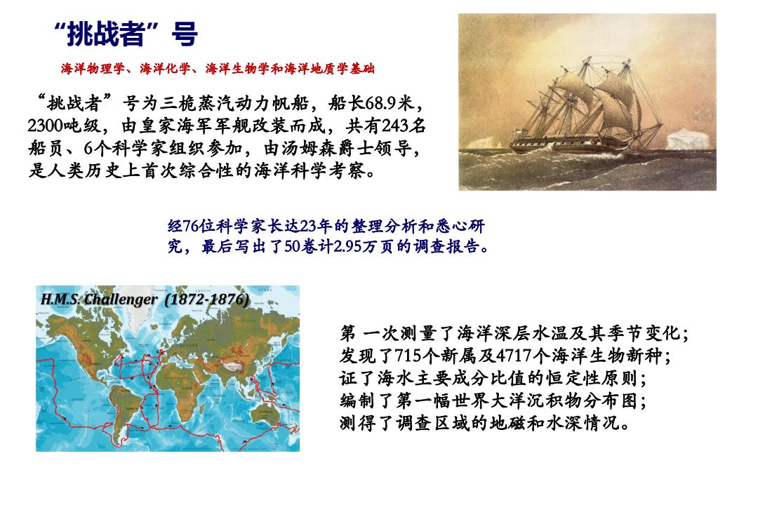
“挑战者”号 海洋物理学、海洋化学、海洋生物学和海洋地质学基础 “挑战者”号为三桅蒸汽动力帆船,船长689米, 2300吨级,由皇家海军军舰改装而成,共有243名 船员、6个科学家组织参加,由汤姆森爵士领导, 是人类历史上首次综合性的海洋科学考察。 经76位科学家长达23年的整理分析和悉心研 究,最后写出了50卷计2.95万页的调查报告。 H.M.S:Challenger (1872-1876) 第一次测量了海洋深层水温及其季节变化; 发现了715个新属及4717个海洋生物新种; 证了海水主要成分比值的恒定性原则; 编制了第一幅世界大洋沉积物分布图; 测得了调查区域的地磁和水深情况
“挑战者”号 “挑战者”号为三桅蒸汽动力帆船,船长68.9米, 2300吨级,由皇家海军军舰改装而成,共有243名 船员、6个科学家组织参加,由汤姆森爵士领导, 是人类历史上首次综合性的海洋科学考察。 第 一次测量了海洋深层水温及其季节变化; 发现了715个新属及4717个海洋生物新种; 证了海水主要成分比值的恒定性原则; 编制了第一幅世界大洋沉积物分布图; 测得了调查区域的地磁和水深情况。 经76位科学家长达23年的整理分析和悉心研 究,最后写出了50卷计2.95万页的调查报告。 海洋物理学、海洋化学、海洋生物学和海洋地质学基础
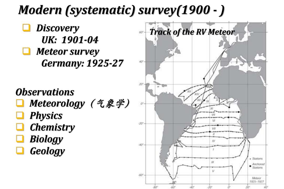
Modern (systematic)survey(1900-) ▣Discovery Track of the RV Meteor UK:1901-04 Meteor survey Germany:1925-27 0 Observations ▣ Meteorology(气象学) ▣Physics Chemistry 20 Biology 40 Geology 。Stanors Anchored Meteor 125-127 40
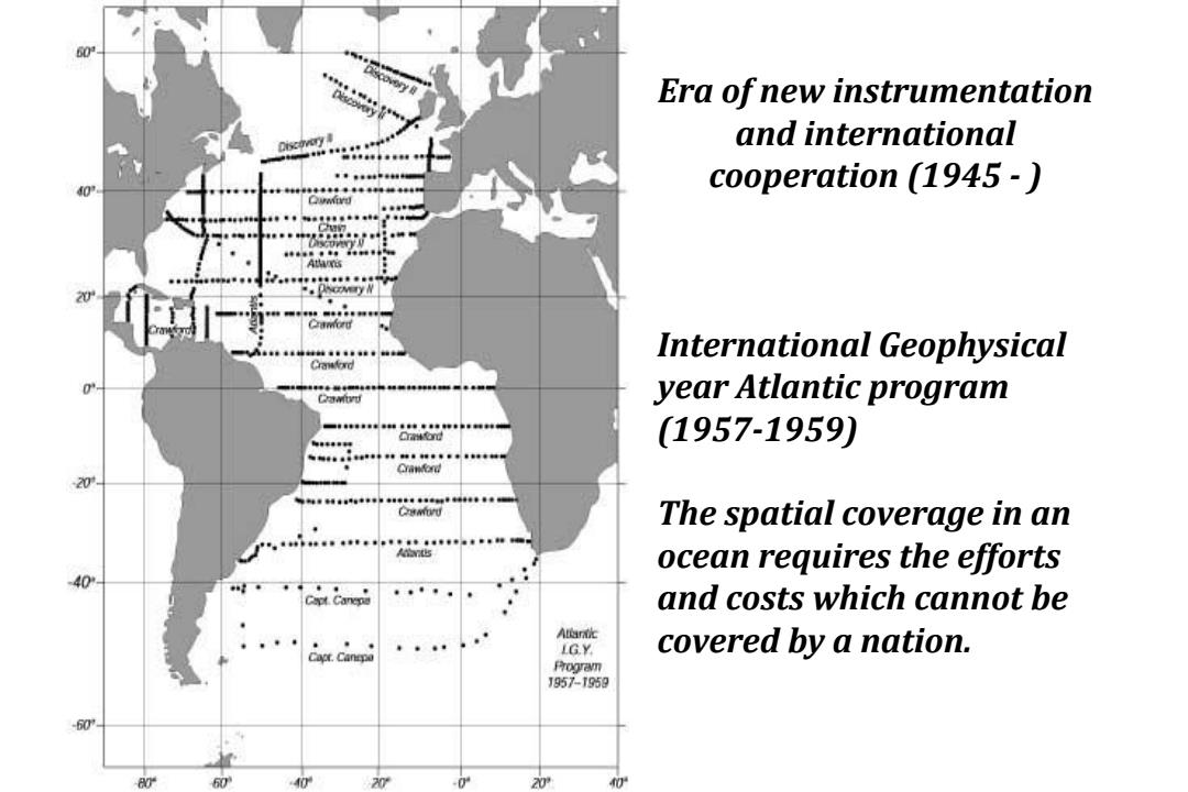
60' Era of new instrumentation and international cooperation (1945 - International Geophysical year Atlantic program Cawo (1957-1959) 20T CuMYU The spatial coverage in an ocean requires the efforts and costs which cannot be A尚r放 LGY. covered by a nation. Rogram J957-1959 60T 20 0
Era of new instrumentation and international cooperation (1945 - ) International Geophysical year Atlantic program (1957-1959) The spatial coverage in an ocean requires the efforts and costs which cannot be covered by a nation

Era of the Earth system(1990-) 知识点 A2 P内PoP雨 。4 P31 5 6 World Ocean Circulation Experiment (WOCE)(1982-2002) 口 Satellites:Topex,SeaWifs,Modis (1980-) 口 Joint Global Ocean Flux Study (JGOFS)(1990s) 口 Global Ocean Ecosystem Dynamics (GLOBEC)(1999-2009) 口 CLIVAR,IMBER,SOLAS,LOICZ,IMAGES/PAGES,InterRidge, InterMARGINS,GEOTRACER Basin-scale Analysis,Synthesis and Integration (BASIN)(2010-
Era of the Earth system (1990 - ) q World Ocean Circulation Experiment (WOCE) (1982-2002) q Satellites: Topex, SeaWifs, Modis (1980 - ) q Joint Global Ocean Flux Study (JGOFS) (1990s) q Global Ocean Ecosystem Dynamics (GLOBEC) (1999-2009) q CLIVAR, IMBER, SOLAS, LOICZ, IMAGES/PAGES, InterRidge, InterMARGINS, GEOTRACER q Basin-scale Analysis, Synthesis and Integration (BASIN) (2010 - 知识点
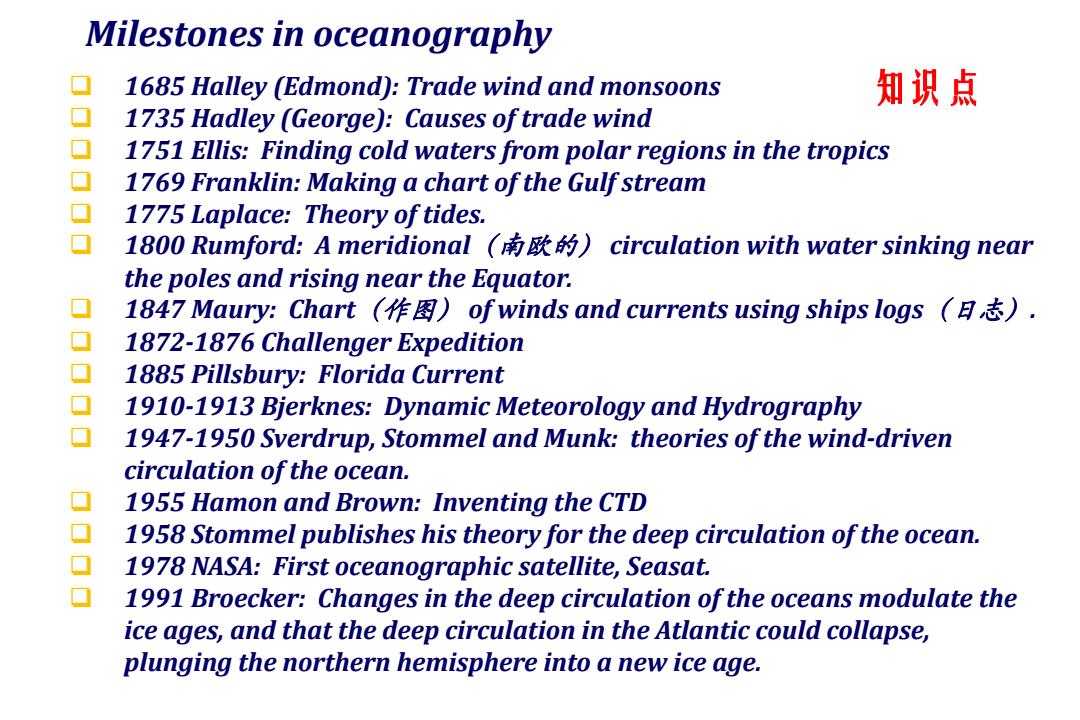
Milestones in oceanography 1685 Halley (Edmond):Trade wind and monsoons 知识点 1735 Hadley (George):Causes of trade wind 1751 Ellis:Finding cold waters from polar regions in the tropics 1769 Franklin:Making a chart of the Gulf stream 1775 Laplace:Theory of tides. 1800 Rumford:A meridional(南欧的)circulation with water sinking near the poles and rising near the Equator. 1847 Maury:Chart(作图)of winds and currents using ships logs(日志). 1872-1876 Challenger Expedition 1885 Pillsbury:Florida Current 1910-1913 Bjerknes:Dynamic Meteorology and Hydrography 1947-1950 Sverdrup,Stommel and Munk:theories of the wind-driven circulation of the ocean. 1955 Hamon and Brown:Inventing the CTD 1958 Stommel publishes his theory for the deep circulation of the ocean. 1978 NASA:First oceanographic satellite,Seasat. 1991 Broecker:Changes in the deep circulation of the oceans modulate the ice ages,and that the deep circulation in the Atlantic could collapse, plunging the northern hemisphere into a new ice age
Milestones in oceanography q 1685 Halley (Edmond): Trade wind and monsoons q 1735 Hadley (George): Causes of trade wind q 1751 Ellis: Finding cold waters from polar regions in the tropics q 1769 Franklin: Making a chart of the Gulf stream q 1775 Laplace: Theory of tides. q 1800 Rumford: A meridional(南欧的) circulation with water sinking near the poles and rising near the Equator. q 1847 Maury: Chart(作图) of winds and currents using ships logs(日志). q 1872-1876 Challenger Expedition q 1885 Pillsbury: Florida Current q 1910-1913 Bjerknes: Dynamic Meteorology and Hydrography q 1947-1950 Sverdrup, Stommel and Munk: theories of the wind-driven circulation of the ocean. q 1955 Hamon and Brown: Inventing the CTD q 1958 Stommel publishes his theory for the deep circulation of the ocean. q 1978 NASA: First oceanographic satellite, Seasat. q 1991 Broecker: Changes in the deep circulation of the oceans modulate the ice ages, and that the deep circulation in the Atlantic could collapse, plunging the northern hemisphere into a new ice age. 知识点
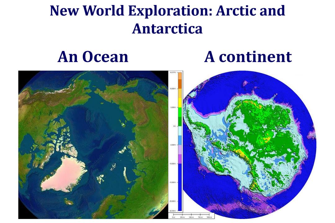
New World Exploration:Arctic and Antarctica An Ocean A continent
An Ocean A continent New World Exploration: Arctic and Antarctica