
Seismic Design of Building Structures
Seismic Design of Building Structures
Part1 BAS I C S E I S MOL OGY l-1 The nature ofearthquakes地震的特点 An earthquake is an oscillatory,sometimes violent movement of the ground's surface that follows a release of energy in the Earth's crust.This energy can be generated by a sudden dislocation of segments of the crust,a volcanic eruption,ora man-made explosion.Most of the destructive earthquakes,however,are caused by dislocations of the crust. When subjected to geologic forces from plate tectonics,the crust initially strains(ie bends and shears)elastically.For pure axial loading,Hooke's law gives the stress that accompanies this strain. 0=Es (axial loading) (1.1) As rock is stressed,it stores strain energy,U.The elastic strain energy per unit volume for pure axial loading is U=GE 2 (axial loading) (12) When the stress exceeds the ultimate strength of the rocks,the rocks break and quickly move (i.e,they "snap')into new positions.In the process of breaking,the strain energy is released and seismic waves are generated.This is the basic description of the elasti rebound theory of earthqu gener These waves travel from the source of the earthquake known as the hypocenter or focus)to move distant locations along the surface of and through the Earth.The wave velocities depend on the nature of the waves and the material through which the waves travel.(See Sec.1-14.)Some of the vibrations are of very low frequency with periods ofm ny onds and thus are inaudible A modern theory may explain how some earthquakes are triggered.Geologists know that pumping fluids into the ground under high pressure can trigger earthquakes Now there is evidence from the gas-producing regions in France that removing fluids from pores deep in the earth can also trigger earthquakes.Oil and gas are the main fluids of concem;pumping water from aquifers close to the surface is probably not as likely to result in ar quake.The theory states that the the gas or oil is removed,but the rocks surrounding the reservoir do not.This results in stresses in the earth that later are released in an earthquake. 1-2 EARTHQUAKETERMINOLOGY The epicenter of an earthquake is the point on the Earth's surface directly above the focus(also known as the hypocenter).The location to an earthquake is commonly described by the geographic position of its epicenter and its local depth. The focal depth of an earthquake is the depth from the Earth's surface to the focus. These terms are illustrated in Fig.1.1. Earthquakes with focal depths of less than approximately 40mi(60 km)are
Part1 BASIC SEISMOLOGY 1-1 The nature of earthquakes 地震的特点 An earthquake is an oscillatory, sometimes violent movement of the ground′s surface that follows a release of energy in the Earth′s crust. This energy can be generated by a sudden dislocation of segments of the crust, a volcanic eruption, or a man-made explosion. Most of the destructive earthquakes, however, are caused by dislocations of the crust. When subjected to geologic forces from plate tectonics, the crust initially strains(i.e., bends and shears) elastically. For pure axial loading, Hooke‵s law gives the stress that accompanies this strain. = E (axial loading) (1.1) As rock is stressed, it stores strain energy, U. The elastic strain energy per unit volume for pure axial loading is 1 U= 2 (axial loading) (1.2) When the stress exceeds the ultimate strength of the rocks, the rocks break and quickly move (i.e, they “snap’) into new positions. In the process of breaking, the strain energy is released and seismic waves are generated. This is the basic description of the elastic rebound theory of earthquake generation. These waves travel from the source of the earthquake known as the hypocenter or focus) to move distant locations along the surface of and through the Earth. The wave velocities depend on the nature of the waves and the material through which the waves travel. (See Sec.1-14.) Some of the vibrations are of very low frequency with periods of many seconds and thus are inaudible. A modern theory may explain how some earthquakes are triggered. Geologists know that pumping fluids into the ground under high pressure can trigger earthquakes. Now there is evidence from the gas-producing regions in France that removing fluids from pores deep in the earth can also trigger earthquakes. Oil and gas are the main fluids of concern; pumping water from aquifers close to the surface is probably not as likely to result in an earthquake. The theory states that the reservoir shrinks when the gas or oil is removed, but the rocks surrounding the reservoir do not. This results in stresses in the earth that later are released in an earthquake. 1-2 EARTHQUAKE TERMINOLOGY The epicenter of an earthquake is the point on the Earth‵s surface directly above the focus(also known as the hypocenter). The location to an earthquake is commonly described by the geographic position of its epicenter and its local depth. The focal depth of an earthquake is the depth from the Earth‵s surface to the focus, These terms are illustrated in Fig.1.1. Earthquakes with focal depths of less than approximately 40mi(60 km) are
classified as shallow earthauakes very shallow earthauakes are caused by the fracturing of brittle rock in the cru teral strain energy that overcom s the aearthquakes are typically shallow Intermediate earthquakes,whose causes are not fully understood,have focal depths ranging from 40-190mi(60 to 300 km).Deep earthquakes may have focal depths of up to 450mi(700 km) The slip eates from the hypocenter along the fault with a velocity y up to that -rad iating seismic shea ar wave fro nt-about 1.8mi/sec(3km/s)-until the entire affected segment is in motion.(See Sec.1-5) 1-3 GLOBALSEISMICITY The United States has experienced less destruction than other countries located in this carthounke on Ts s pak dne to the young age and attention to earthquak e-resistant construction met ut millio Am cans nov live in potentia l earthquake areas.Large parts of the western United States are known to be vulnerable to damage from earthquakes.Nowhere is this more true than in Califomia.Nuclear reactors,dams,schools,hospitals,and high-rise building are planned and built in locations of high seismic hazard.This has created an urgent need for greater attention to the mitigation of earthquake-induced damage 1-4 CONTINENTALDRIFT It has been known since the early 1900s that the continents are moving relative to one another,movement known as continental drift.In fact,fossilized records of past climates(the subject of the field of paleoclimatology)indicate that the continents have been moving s about the nhe r hundreds nillions of years example,the same 300-million-year-old fossilized deposits are found in India and in the Arctic. The theory of continental drift was reasonably established during the 1930s.the emerging science of paleomagnetism provided new supporting evidence of contine tal drift.Many ro ks lcanic rock solidified fro ten lava contain tiny grains of magnetic minerals such an magnetite.When these minerals are formed.they retain the magnetic orientation of the Earth's magnetic orientations of rocks suggest by paleoclimatology and other geologic criteria. An enormous amount of geophysical data was gathered during the 1950s and 1960s,particularly from oceanog aphic research vessels such as the Omar Challenger. A system of i interconnecting submarine ridges.called mid- ocean ridges,was discovered circling the Earth.Such ridges are located approximately midway between continents that are moving apart (e.g.,between Africa and South America).It is now recognized that new oceanic crust is being formed at the ridges and is added to the plates moving apart.This is known as seafloor spreading Grea e trenches ere also locat particularly along oceanic sides of the volcanic arcs that make up the Pacific ring of fire.Inclined zones of earthquakes dip down from these trenches to as deep as 450 mi(700km)into the mantle beneath and behind the volcanic arcs.Oceanic crust is formed at spreading ridges behind the moving plates
classified as shallow earthquakes .Very shallow earthquakes are caused by the fracturing of brittle rock in the crust or by internal strain energy that overcomes the friction locking opposite sides of a fault, California earthquakes are typically shallow. Intermediate earthquakes, whose causes are not fully understood, have focal depths ranging from 40-190mi (60 to 300 km). Deep earthquakes may have focal depths of up to 450mi(700 km) The slip propagates from the hypocenter along the fault with a velocity up to that of the outward-radiating seismic shear wave front –about 1.8mi/sec(3km/s)-until the entire affected segment is in motion.(See Sec.1-5) 1-3 GLOBALSEISMICITY The United States has experienced less destruction than other countries located in this earthquake zone. This is partly due to the country’s relatively young age and attention to earthquake-resistant construction methods, but millions of Americans now live in potential earthquake areas. Large parts of the western United States are known to be vulnerable to damage from earthquakes. Nowhere is this more true than in California. Nuclear reactors, dams, schools, hospitals, and high-rise building are planned and built in locations of high seismic hazard. This has created an urgent need for greater attention to the mitigation of earthquake-induced damage. 1-4 CONTINENTAL DRIFT It has been known since the early 1900s that the continents are moving relative to one another, movement known as continental drift. In fact, fossilized records of past climates (the subject of the field of paleoclimatology) indicate that the continents have been moving slowly about the globe for hundreds of millions of years. For example, the same 300-million-year-old fossilized deposits are found in India and in the Arctic. The theory of continental drift was reasonably established during the 1930s, the emerging science of paleomagnetism provided new supporting evidence of continental drift. Many rocks, such as volcanic rock solidified from molten lava, contain tiny grains of magnetic minerals such an magnetite. When these minerals are formed, they retain the magnetic orientation of the Earth’s magnetic orientations of rocks suggest by paleoclimatology and other geologic criteria. An enormous amount of geophysical data was gathered during the 1950s and 1960s, particularly from oceanographic research vessels such as the Omar Challenger. A system of interconnecting submarine ridges, called mid-ocean ridges, was discovered circling the Earth. Such ridges are located approximately midway between continents that are moving apart (e.g., between Africa and South America). It is now recognized that new oceanic crust is being formed at the ridges and is added to the plates moving apart. This is known as seafloor spreading. Great submarine trenches were also located, particularly along the convex oceanic sides of the volcanic arcs that make up the Pacific ring of fire. Inclined zones of earthquakes dip down from these trenches to as deep as 450 mi(700km) into the mantle beneath and behind the volcanic arcs. Oceanic crust is formed at spreading ridges behind the moving plates
The ocean crust,known to consist of altemating belts of highly and weakly magnetic oceanic crust material,represents magnetic records as new cr st forms in the gaps behind separating plates.The symmetrical belts record the ambient magnetism on opposite sides of the newly formed ridges. The crust is destroyed at the same rate elsewhere as oceanic plates dip down at the trenches and slide deep into the mantle along the seismic zones.However,there is a global balance between crust formation and destruction.The formation of plat material in the Atlantic Ocean is compensated by absorption of plate material, primarily in the Pacific Ocean. 1-5 PLATE TECTONICS Most earthquakes are manifestation of the fragmentation of the Earth's oute shell (known as the lithosph ere)into various large and sma I plates (The academic field that studies plate motion is known as plate tectonics.)There are seven very large plates,each consisting of both oceanic and continental portions.There are also a dozen or more small plates,not all of which are shown in Fig.1.2. Each plate is approximately 50 to 60mi(8 to 100km)thick and has thick and thin parts e thi by elastic bending and brittle b The thick part yields plastically.Beneath the plate is a viscous layer on which the entire plate slides.The plates themselves tend to be interally rigid,interacting only at the edges. These plates move relative to each other with steady velocities that approach 0.4ftlyr(0.13m/a)Although plate velocities are slow by human standards,they are rapi geological 30 mi(50km)in only or example,a m on of 0.15ft/yr(0.13m/a)ad d up million years.Some plate motions have been continuous for 100 million years. Depending on location,the plates can be moving apart,colliding slowly to build mountain ranges,or slipping laterally past or sliding over and underone another. 1-6 SUBMARINE RIDGES Where plates are pulling apart,particularly along the system of submarine ridges,hot material from the deeper mantle wells up to fill the gap.Some of the mantle material appears as lava in volcanic material.Most solidifies beneath the surface,forming a submarine ridge.The ridge is high relative to the ocean bottom because the mantle mate erial is ho and.hence low in density As the plates move apart,the ridge material gradually cools and contracts and its surface sinks.Ridges generally form step-like alterations in height perpendicular to the direction of plate motion.Strike-slip faults form parallel to the direction of plate motion.(See Sec.1-10.) 1-7SUBMARINE TRENCHES Where plates converge,one dips down and slides beneath the other in a process known as subduction.Generally,an oceanic plate slides,or subducts,beneath a continental plate (as is happening along the west coast of South America)or beneath another oceanic plate(as is happening along the east side of the Philippine Sea plate)
The ocean crust, known to consist of alternating belts of highly and weakly magnetic oceanic crust material, represents magnetic records as new crust forms in the gaps behind separating plates. The symmetrical belts record the ambient magnetism on opposite sides of the newly formed ridges. The crust is destroyed at the same rate elsewhere as oceanic plates dip down at the trenches and slide deep into the mantle along the seismic zones. However, there is a global balance between crust formation and destruction. The formation of plate material in the Atlantic Ocean is compensated by absorption of plate material, primarily in the Pacific Ocean. 1-5 PLATE TECTONICS Most earthquakes are a manifestation of the fragmentation of the Earth’s outer shell (known as the lithosphere) into various large and small plates. (The academic field that studies plate motion is known as plate tectonics.) There are seven very large plates, each consisting of both oceanic and continental portions. There are also a dozen or more small plates, not all of which are shown in Fig.1.2. Each plate is approximately 50 to 60mi (80 to 100km) thick and has thick and thin parts. The thinner part deforms by elastic bending and brittle breakage. The thicker part yields plastically. Beneath the plate is a viscous layer on which the entire plate slides. The plates themselves tend to be internally rigid, interacting only at the edges. These plates move relative to each other with steady velocities that approach 0.4ft\yr(0.13m/a) 6 .Although plate velocities are slow by human standards, they are extremely rapid geologically. For example, a motion of 0.15ft/yr (0.13m/a) add up to 30 mi (50km) in only 1 million years. Some plate motions have been continuous for 100 million years. Depending on location, the plates can be moving apart, colliding slowly to build mountain ranges, or slipping laterally past or sliding over and under one another. 1-6 SUBMARINE RIDGES Where plates are pulling apart,particularly along the system of submarine ridges, hot material from the deeper mantle wells up to fill the gap. Some of the mantle material appears as lava in volcanic material. Most solidifies beneath the surface, forming a submarine ridge. The ridge is high relative to the ocean bottom because the mantle material is hot and, hence, low in density. As the plates move apart, the ridge material gradually cools and contracts and its surface sinks. Ridges generally form step-like alterations in height perpendicular to the direction of plate motion. Strike-slip faults form parallel to the direction of plate motion.(See Sec.1-10.) 1-7SUBMARINE TRENCHES Where plates converge, one dips down and slides beneath the other in a process known as subduction. Generally, an oceanic plate slides, or subducts,beneath a continental plate (as is happening along the west coast of South America) or beneath another oceanic plate(as is happening along the east side of the Philippine Sea plate)
a trench is formed where the subducting plate dins down The sediment from the floor is scraped off against the front edge of the top plate.This is illustrated in Fig.1. Far back under the top plate,inclined zones of earthquakes reach down into the mantle.The average depth of these zones is approximately 80mi(125km),but the zones can approach 450mi(700km)in depth.The hypocenters of earthquakes in these zones indic e the trajectory of the subducted plate belt olcanoes typicall occurs s above this earthquake one,roughly paralleling the plate edges.(The Pacific Ocean coastal region of South America is typical of such an area.)Rock melting.which ultimately produces the volcanoes, starts when water combined in the crystalline structures of various minerals,or otherwise trapped,is removed by the increase in pressure on the subducted plate.The water loss lowers the net energy required to melt the remaining rock 1-8 EARTHQUAKEENERGY RELEASE Shallow earthquakes represent sudden slippages and are accompanied by a release of elastic strain energy stored in the rock over a long period.It is not totally p mantle ompanied by releas s(ie.the elastic rebound theory)or are merely abrupt part of the subducting plateinto rock of higher density(ie.an aspect of the dilatational theory).However,recent research seems to indicate the former explanation is more appropriate than the latter Only a fraction of the energy released in an earthauake actually appears in seismic waves Most of the release train energy is orbed locally by the moving. deforming,and heating of the rock.The fraction absorbed increases irregularly with increasing size of earthquakes.Minor earthquakes generally do not represent a sufficient release of energy to dissipate the strain energy and prevent great earthquakes,although a slow creep along a fault can provide a partial release,A great earthquake.h does ot n ssarily rel ase all of the stra y either Great earthquakes occur primarily along convergent (subducting)plate boundaries.Submerged ridges (where plates are spreading apart)are so hot relatively shallow depths that the solid rock above them cannot store enough elastic strain energy to produce great earthquakes.The infrequent large earthquakes that do occur in these ridge systems are mostly on the longer strike-slip faults.(See Sec.-) 1-9 SEISMIC SEA WAVES When the seafloor suddenly rises up during a great earthquake,water also rises with it and then rushes away to find a level surface.If the floor drops,water rushes in. An enormous mass of water is suddenly set in motion,and a complex sloshing back and forth between cor for many ours.The resu It is s a train of surface-water waves,each of which is known as a seismic sea wave(also known as a tidal wave),or,in Japanese,a tsunami.The most pronounced sudden changes in seafloor depth,and hence the greatest sea waves,result from shallow subduction-zone earthquakes
A trench is formed where the subducting plate dips down. The sediment from the ocean floor is scraped off against the front edge of the top plate. This is illustrated in Fig.1.3. Far back under the top plate, inclined zones of earthquakes reach down into the mantle. The average depth of these zones is approximately 80mi(125km), but the zones can approach 450mi(700km) in depth. The hypocenters of earthquakes in these zones indicate the trajectory of the subducted plate. A belt of volcanoes typically occurs above this earthquake zone, roughly paralleling the plate edges. (The Pacific Ocean coastal region of South America is typical of such an area.) Rock melting, which ultimately produces the volcanoes, starts when water combined in the crystalline structures of various minerals, or otherwise trapped, is removed by the increase in pressure on the subducted plate. The water loss lowers the net energy required to melt the remaining rock. 1-8 EARTHQUAKE ENERGY RELEASE Shallow earthquakes represent sudden slippages and are accompanied by a release of elastic strain energy stored in the rock over a long period. It is not totally clear whether deep mantle subduction-zone earthquakes are accompanied by similar elastic releases (i.e., the elastic rebound theory) or are merely abrupt contractions of part of the subducting plateinto rock of higher density(i.e., an aspect of the dilatational theory).However, recent research seems to indicate the former explanation is more appropriate than the latter. Only a fraction of the energy released in an earthquake actually appears in seismic waves. Most of the released strain energy is reabsorbed locally by the moving, deforming, and heating of the rock. The fraction absorbed increases irregularly with increasing size of earthquakes. Minor earthquakes generally do not represent a sufficient release of energy to dissipate the strain energy and prevent great earthquakes, although a slow creep along a fault can provide a partial release, A great earthquake, however, does not necessarily release all of the strain energy either. Great earthquakes occur primarily along convergent (subducting) plate boundaries. Submerged ridges (where plates are spreading apart) are so hot relatively shallow depths that the solid rock above them cannot store enough elastic strain energy to produce great earthquakes. The infrequent large earthquakes that do occur in these ridge systems are mostly on the longer strike-slip faults. (See Sec.-) 1-9 SEISMIC SEA WAVES When the seafloor suddenly rises up during a great earthquake, water also rises with it and then rushes away to find a level surface. If the floor drops, water rushes in. An enormous mass of water is suddenly set in motion, and a complex sloshing back and forth between continents continues for many hours. The result is a train of surface-water waves, each of which is known as a seismic sea wave (also known as a tidal wave), or, in Japanese, a tsunami. The most pronounced sudden changes in seafloor depth, and hence the greatest sea waves, result from shallow subduction-zone earthquakes
As with any surface wave orsurge wave,the velocity ofa tsunami depends on the ocean depth.In deep ocean,waves travel at about 500mi/hr (800km/h).The waves at sea may be an hour apart and perhaps only 1 ft (0.3m)in height.Combined with a wave period of 5 to 0 min,they are virtually undetectable As a wave approaches land,however,the wave velocity decreases due to increased friction with the increasingly shallow seafloor.As the wave velocity decreases,the wave height increases Where seafloor topography and orceantation are optimal for tsunami formation (Where there is a gently sloping seafloor and where the slope is parallel to wave direction),the wave can form a wall of water more than 50ft(15m)in height.Such a wave can cause enormous destruction when it rushes onto shore.Nearby coastal where the bottom configuration is much different(i.e.more abrupt in depth e the same wave pass as only a rapid surge and withdrawal of water Only normal (dip-slip)and thrust (reverse)faults produce tsunamis.The greater the depth of water,the larger the energy content of the tsunami. 1-10FAULTS A fault is a fracture in the Earth's crust along which two blocks slip relative to each other.One crustal block may move horizontally in one direction while the opposite block moves horizontally in the opposite direction.Altnatively.one block may move upward while the other moves downward. One of the ways movement along faults can occur is by sudden displacement or slip,of the ock along a fault.Dur rthquake.the und was dislaeed s much 2 f Clfom the San Andreas Fault.By comparison.the 1989 Loma Prieta earthquake had a maximum displacement of approximately 6ft(2m). Most of the faults in California are vertical or nearvertical breaks.Movement along these breaks is predominantly horizontal in the northerly or north we direction.With right lateral movement(such a the e movement of earthqua kes s in th San Andreas system),a block on the opposite side of the fault(relative to an observer) moves to the right.Conversely.the block moves to the left in a left-lateral fault Lateral movement is produced by strike-slip(wrench)faults A fault in which the movement is vertical is called a dip-slip fault.In a normal fault,the ha down relative to the foot wall.In reve fault,also known as a thrust fault,the hanging wall moves up relative to the foot wall. Along many faults movement is both horizontal and vertical.Such faults are named by combining the names of each kind of movement.For example.Fig.1.4 shows a left-lateral normal fault.The term oblique fault is also used. A few re se faults ha ve in Calif ia The pla es of such faults are inclined to the Earth's surface.The rocks above the fault plane e have been thrus upward and over the rocks below the fault plane.The Arvin-Tehachapi earthquake of 1952 was caused by the White Wolf reverse fault.The San Fernando earthquake of 1971 was caused by a sudden rupture along a reverse fault at the foot of the san Gabriel mountains
As with any surface wave or surge wave, the velocity of a tsunami depends primarily on the ocean depth. In deep ocean, waves travel at about 500mi/hr (800km/h). The waves at sea may be an hour apart and perhaps only 1 ft (0.3m) in height. Combined with a wave period of 5 to 0 min, they are virtually undetectable. As a wave approaches land, however, the wave velocity decreases due to increased friction with the increasingly shallow seafloor. As the wave velocity decreases, the wave height increases. Where seafloor topography and orceantation are optimal for tsunami formation (Where there is a gently sloping seafloor and where the slope is parallel to wave direction), the wave can form a wall of water more than 50ft(15m) in height. Such a wave can cause enormous destruction when it rushes onto shore. Nearby coastal points , where the bottom configuration is much different(i.e., more abrupt in depth change), may see the same wave pass as only a rapid surge and withdrawal of water. Only normal (dip-slip) and thrust (reverse) faults produce tsunamis. The greater the depth of water, the larger the energy content of the tsunami. 1-10FAULTS A fault is a fracture in the Earth’s crust along which two blocks slip relative to each other. One crustal block may move horizontally in one direction while the opposite block moves horizontally in the opposite direction,. Altnatively, one block may move upward while the other moves downward. One of the ways movement along faults can occur is by sudden displacement, or slip, of the crust or rock along a fault. During the 1906 San Francisco earthquake, the ground was displaced as much as 21 ft(6.5m) in northern California along the San Andreas Fault. By comparison, the 1989 Loma Prieta earthquake had a maximum displacement of approximately 6ft (2m). Most of the faults in California are vertical or nearvertical breaks. Movement along these breaks is predominantly horizontal in the northerly or north westerly direction. With right-lateral movement(such as the movement of earthquakes in the San Andreas system), a block on the opposite side of the fault (relative to an observer) moves to the right. Conversely, the block moves to the left in a left-lateral fault. Lateral movement is produced by strike-slip(wrench) faults. A fault in which the movement is vertical is called a dip-slip fault. In a normal fault, the hanging wall moves down relative to the foot wall. In a reverse fault, also known as a thrust fault, the hanging wall moves up relative to the foot wall. Along many faults movement is both horizontal and vertical. Such faults are named by combining the names of each kind of movement. For example, Fig.1.4 shows a left-lateral normal fault. The term oblique fault is also used. A few reverse faults have been active in California. The planes of such faults are inclined to the Earth’s surface. The rocks above the fault plane have been thrust upward and over the rocks below the fault plane. The Arvin-Tehachapi earthquake of 1952 was caused by the White Wolf reverse fault. The San Fernando earthquake of 1971 was caused by a sudden rupture along a reverse fault at the foot of the San Gabriel Mountains

1-11CALIFORNIA FAULTS The most earthquake-prone areas in the United States are those that are adjacent to the San Andreas Fault system of California,as well as the fault system that separates the sierra nevada from the great basin.many of the individual faults of these major systems are known to have been active during the past 200 years.Others 肥o82 been ct since the ed of the gre at ice ad nce abou g the past 200 years,many of the fau Its shown in Fig.1.5hav experienced either sudden slip or slow creep.Activity of other faults,however,can only be inferred from geologic and topographic relations that ind icate the faults have been active during the past several thousand years.Such activity suggests that these faults could slip or cree again.(See Sec.1-13.) are relatively shallow and are clearly related o movement along active faults.Many Califomnia earthquakes have produced surface rupture. 1-12 SAN ANDREAS FAULT rfault of a network that cuts through rocks of omia coastal region.This right-lateral fault s a huge fracture e more thar 600mi(950km)long.It extends almost vertically into the Earth to a depth of at least 20 mi (30km).In detail,it is a complex zone of crushed and broken rock from only a few feet wide to a mile wide.Many smaller faults branch from and join the San Andreas Fault. A linear trough in the surface of the Earth reveals the presence of the Sa Andreas Fault over much of its length.From the air,the linear arrangements of lakes. bays,and valleys are apparent.On the ground.The fault zone can be recognized by long,straight escarpments,narrow ridges,and small,undrained ponds formed by the settling of small areas of rock.However.people on the ground usually do not realize when the on near the fault. Geologists who have studied the fault between Los Angeles and San Francisco have suggested that the total accumulated displacement along the fault may be as much as 350mi (550km).Similarly,geological study of a segment of the fault between the Teion pass and the salton sea has revealed geologically similar terrains on opposite sides of the fault separated by 150 mi (250k km).This indicates that the separation is a result of movement along the San Andreas an nd branching San Gabriel faults Since 1934,earthquake activity along the San Andreas Fault system has been concentrated in three areas:(1)an off-shore area at the northernmost tip of the fault known as the Merdocino fracture zone.(2)the area along the fault between San isco and Parkfield,and (3)the sectio ughly bou Los Angeles and the border with Mexico.Creep,slip,and moderate earthquakes have occurred on a regular basis in these areas. The two zones between these three active areas have had almost no earthquakes or known slip since the great earthquakes of 1857 in the southem segment and 1906
1-11CALIFORNIA FAULTS The most earthquake-prone areas in the United States are those that are adjacent to the San Andreas Fault system of California, as well as the fault system that separates the Sierra Nevada from the Great Basin. Many of the individual faults of these major systems are known to have been active during the past 200 years. Others are believed to have been active since the end of the last great ice advance about 10,000 years ago. During the past 200 years, many of the faults shown in Fig.1.5 have experienced either sudden slip or slow creep. Activity of other faults, however, can only be inferred from geologic and topographic relations that indicate the faults have been active during the past several thousand years. Such activity suggests that these faults could slip or creep again. (See Sec.1-13.) Earthquakes in California are relatively shallow and are clearly related to movement along active faults. Many California earthquakes have produced surface rupture. 1-12 SAN ANDREAS FAULT The San Andreas Fault is the major fault of a network that cuts through rocks of the California coastal region. This right-lateral fault is a huge fracture more than 600mi (950km) long. It extends almost vertically into the Earth to a depth of at least 20 mi (30km). In detail, it is a complex zone of crushed and broken rock from only a few feet wide to a mile wide. Many smaller faults branch from and join the San Andreas Fault. A linear trough in the surface of the Earth reveals the presence of the San Andreas Fault over much of its length. From the air, the linear arrangements of lakes, bays, and valleys are apparent. On the ground. The fault zone can be recognized by long, straight escarpments, narrow ridges, and small, undrained ponds formed by the settling of small areas of rock. However ,people on the ground usually do not realize when they are on or near the fault. Geologists who have studied the fault between Los Angeles and San Francisco have suggested that the total accumulated displacement along the fault may be as much as 350mi (550km). Similarly, geological study of a segment of the fault between the Tejon Pass and the Salton Sea has revealed geologically similar terrains on opposite sides of the fault separated by 150 mi (250km). This indicates that the separation is a result of movement along the San Andreas and branching San Gabriel faults. Since 1934, earthquake activity along the San Andreas Fault system has been concentrated in three areas: (1) an off-shore area at the northernmost tip of the fault known as the Mendocino fracture zone,(2) the area along the fault between San Francisco and Parkfield, and (3) the southernmost fault section roughly bounded by Los Angeles and the border with Mexico. Creep, slip, and moderate earthquakes have occurred on a regular basis in these areas. The two zones between these three active areas have had almost no earthquakes or known slip since the great earthquakes of 1857 in the southern segment and 1906
in the northem segment.This implies that these two zones of the San Andreas Fault system are temporarily locked and that strain energy is building.The lack of seismi activity in the locked sections could mean that the sections are subject to less frequent but larger fault movements and,correspondingly,more severe earthquakes. 1-13 CREEP In addition to fault rupture,a second type of fault movement known as creep can occur.Creep is characterized by continuous or intermittent movement without noticeable earthquakes.Fault creep occurring on portions of the Hayward,Calaveras, and San Andreas faults has produced cumulative offsets ranging from mere millimeters to almost Ift(0.3m)in curbs.streets.and railroad tracks. The offsets observed seem consistent with the creep rate measured.Precise surveying shows a slow drift approaching 2 in/yr(5cm/yr)in some places along the San Andreas Fault.Over 350 mi (550 km)of offset has occurred during the past 100 million vears. 1-14 SEISMIC WAVES Seismic waves are of three types:compression,shear,and surfac e waves Compression and shear waves travel from the hypocenter through the Earth's molter core.Because compression waves (also known as longitudinal waves)travel at great speeds(19,000 ft/sec,or 5800m/s,in granite)and ordinarily reach the surface first, they are known as P-waves(for"primary waves"). P-wave velocity is given by Eq.1.3. Vp= a+2G)8 [U.S.] [1.3(a)] 0 [SI] [1.3b】 In Eq.1.3,is Lame's constant, 1=GE-2G」 E 3G-E(1+v)1-2) Shear waves (also known as transverse waves)do not travel as rapidly (10,000ft/sec,or 3000m/s,in granite)through the Earth's crust and mantle as do compression waves.Because they ordinarily reach the surface later,they are known as es(for“s aves").Instead of affecting material directly behind or ahead f their ve shear waves disp material at right anglest path.Equation 1.4 gives the velocity of S-waves.While S-waves travel more slowly than P-waves,they transmit more energy and cause the majority of damage to structures
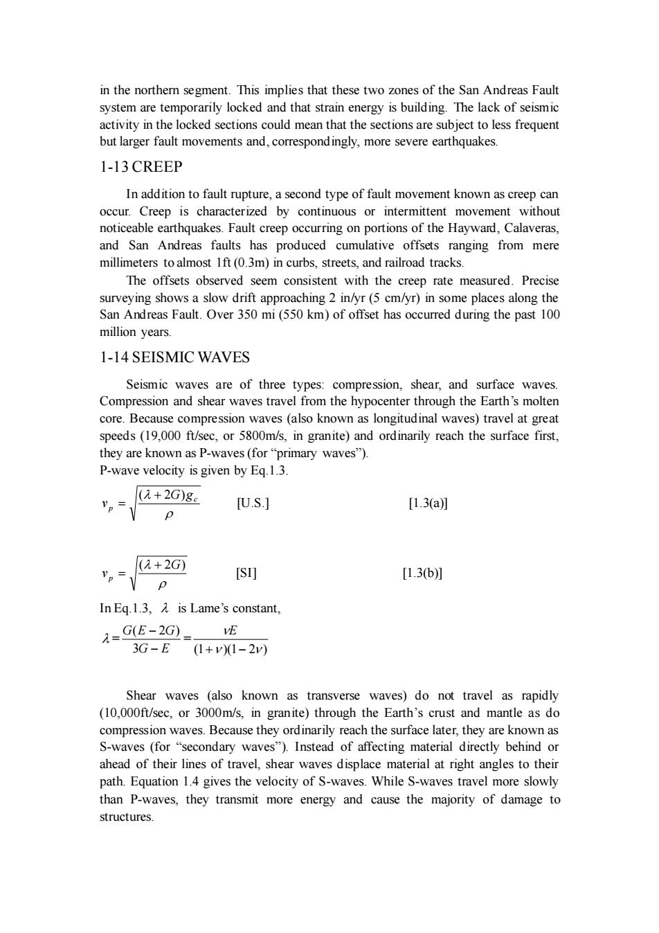
in the northern segment. This implies that these two zones of the San Andreas Fault system are temporarily locked and that strain energy is building. The lack of seismic activity in the locked sections could mean that the sections are subject to less frequent but larger fault movements and, correspondingly, more severe earthquakes. 1-13 CREEP In addition to fault rupture, a second type of fault movement known as creep can occur. Creep is characterized by continuous or intermittent movement without noticeable earthquakes. Fault creep occurring on portions of the Hayward, Calaveras, and San Andreas faults has produced cumulative offsets ranging from mere millimeters to almost 1ft (0.3m) in curbs, streets, and railroad tracks. The offsets observed seem consistent with the creep rate measured. Precise surveying shows a slow drift approaching 2 in/yr (5 cm/yr) in some places along the San Andreas Fault. Over 350 mi (550 km) of offset has occurred during the past 100 million years. 1-14 SEISMIC WAVES Seismic waves are of three types: compression, shear, and surface waves. Compression and shear waves travel from the hypocenter through the Earth’s molten core. Because compression waves (also known as longitudinal waves) travel at great speeds (19,000 ft/sec, or 5800m/s, in granite) and ordinarily reach the surface first, they are known as P-waves (for “primary waves”). P-wave velocity is given by Eq.1.3. c p G g v ( + 2 ) = [U.S.] [1.3(a)] ( 2G) v p + = [SI] [1.3(b)] In Eq.1.3, is Lame’s constant, = G E G E G − − 3 ( 2 ) = (1 )(1 2 ) + − E Shear waves (also known as transverse waves) do not travel as rapidly (10,000ft/sec, or 3000m/s, in granite) through the Earth’s crust and mantle as do compression waves. Because they ordinarily reach the surface later, they are known as S-waves (for “secondary waves”). Instead of affecting material directly behind or ahead of their lines of travel, shear waves displace material at right angles to their path. Equation 1.4 gives the velocity of S-waves. While S-waves travel more slowly than P-waves, they transmit more energy and cause the majority of damage to structures
v.-Te [U.S] [1.4a [SI] [1.4b] Surface waves,also known as R-waves (for"Rayleigh waves")or L-waves(for "Rayleigh waves"),may or may not form.They arrive after the primary and secondary waves.In granite,R-waves move at approximately 9000ft/sec(2700m/s) 1-15LOCATING THE EPICENTER The first indication of an earthquake will often be a sharp'thud"signaling the arrival of the compression wave front.This will be followed by the shear w aves a and then the gound oll used by the surface waves.The timesseparating the rivals of the compression and shear waves at various seismometer stations can be used to locate the epicenter's position and depth. The distance,s,from a seismometer to the epicenter can be determined from the wave velocities and the observed time between the arrival of the compression (P-)and shear (S-)waves ,-4,=(2- [1.5] V Vp The epicenter and hypocenter correspond to the locations of initial fault slip but do and energy release are relatively close.For larger earthquakes,however,hundreds of kilometers can separate the two
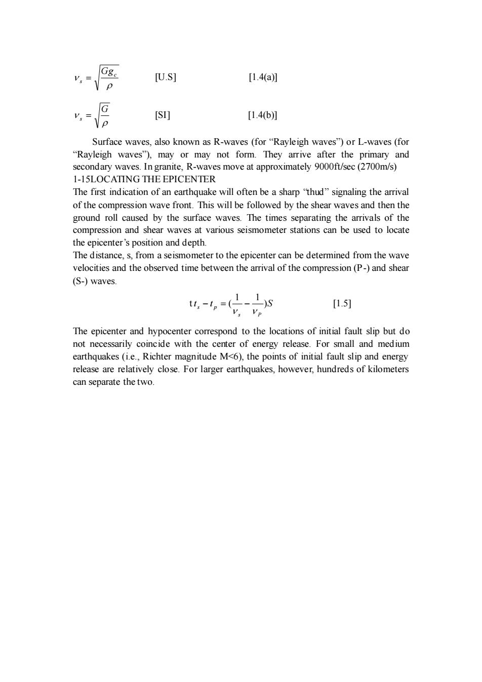
c s Gg = [U.S] [1.4(a)] G s = [SI] [1.4(b)] Surface waves, also known as R-waves (for “Rayleigh waves”) or L-waves (for “Rayleigh waves”), may or may not form. They arrive after the primary and secondary waves. In granite, R-waves move at approximately 9000ft/sec (2700m/s) 1-15LOCATING THE EPICENTER The first indication of an earthquake will often be a sharp “thud” signaling the arrival of the compression wave front. This will be followed by the shear waves and then the ground roll caused by the surface waves. The times separating the arrivals of the compression and shear waves at various seismometer stations can be used to locate the epicenter’s position and depth. The distance, s, from a seismometer to the epicenter can be determined from the wave velocities and the observed time between the arrival of the compression (P-) and shear (S-) waves. t t t S s P s p ) 1 1 ( − = − [1.5] The epicenter and hypocenter correspond to the locations of initial fault slip but do not necessarily coincide with the center of energy release. For small and medium earthquakes (i.e., Richter magnitude M<6), the points of initial fault slip and energy release are relatively close. For larger earthquakes, however, hundreds of kilometers can separate the two
Part2 Earthquake Characteristics 2-1 Intensity scale(烈度表) seismic intensity (not to be confused with magnitude)is based on the damage and other observed effects on people,building,and other features.Intensity varies from place to place within the disturbed region.An earthquake in a densely populated area that results in many deaths and considerable damage may have the sam magnitude as a shock in a remote area that does nothing more than frighten the wildlife.Large magnitude earthquakes that occur beneath the oceans may not even be felt by humans. An intensity scale consists of a series of responses,such as people awakening fumiture moving,and chimneys being damaged.Although numerous intensity scales have heen deve eloped,the scale ountered most often in the United States is the Modified Mercalli Intensity scale,developed in 1931 by the American seismologists Harry Wood and Frank Neumann. The Modified Mercalli scale consists of 12 increasing levels of intensity (expressed as Roman numerals following the initials MM)that range from The lower num of the intensity scale generally are based on the manner in which the earthquake is felt by people.The numerals do not have a mathematical basis and therefore are more meaningful to nontechnical people than to those in technical fields. Modified Mercalli Intensity Scale Intensity rved effects of ea pt by very few under especially favorable conditio Felt only by a few persons at rest,especially by those on upper floors of buildings.Delicately suspended objects may swing. Felt quite noticeably by persons indoors,especially in upper floors of buildings.Many people do not recognize it as an earthquake. Standing ehicles ock slightly. ibrations similar to the Duration estimated During the day,felt indoors by many outdoors by a few.At night, some awakened.Dishes,windows,doors disturbed:walls make cracking sound Sensation like heavy truck striking building Standing vehicles rock noticeably Felt by nearly everyone:Many awakened.Some dishes, windows broken.Unstable objects overturned.Pendulum clocks may stop. Felt by all,many frightened.Some heavy fumiture moved.A few instances of fallen plaster。Damage sight。 Damage negligible in buildings of good design and considerable damage in p ly built stru tures. Some chimneys broker Damage slight in especially designed structures:considerable damage in ordinary substantial buildings,with partial collapse.Damage great in poorly built structures.Fallen chimneys,factory stacks,columns, monuments.walls.Heavy furniture overturned a
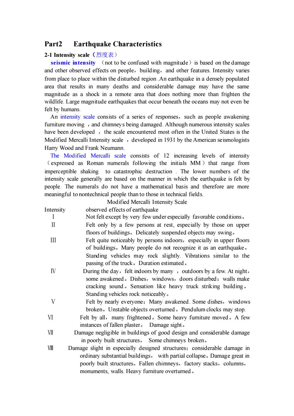
Part2 Earthquake Characteristics 2-1 Intensity scale(烈度表) seismic intensity (not to be confused with magnitude)is based on the damage and other observed effects on people,building,and other features. Intensity varies from place to place within the disturbed region .An earthquake in a densely populated area that results in many deaths and considerable damage may have the same magnitude as a shock in a remote area that does nothing more than frighten the wildlife. Large magnitude earthquakes that occur beneath the oceans may not even be felt by humans. An intensity scale consists of a series of responses,such as people awakening furniture moving ,and chimneys being damaged. Although numerous intensity scales have been developed ,the scale encountered most often in the United States is the Modified Mercalli Intensity scale ,developed in 1931 by the American seismologists Harry Wood and Frank Neumann. The Modified Mercalli scale consists of 12 increasing levels of intensity (expressed as Roman numerals following the initials MM)that range from imperceptible shaking to catastrophic destruction . The lower numbers of the intensity scale generally are based on the manner in which the earthquake is felt by people. The numerals do not have a mathematical basis and therefore are more meaningful to nontechnical people than to those in technical fields. Modified Mercalli Intensity Scale Intensity observed effects of earthquake Ⅰ Not felt except by very few under especially favorable conditions。 Ⅱ Felt only by a few persons at rest, especially by those on upper floors of buildings。Delicately suspended objects may swing。 Ⅲ Felt quite noticeably by persons indoors,especially in upper floors of buildings。Many people do not recognize it as an earthquake。 Standing vehicles may rock slightly. Vibrations similar to the passing of the truck。Duration estimated。 Ⅳ During the day,felt indoors by many ,outdoors by a few. At night, some awakened。Dishes,windows,doors disturbed;walls make cracking sound。Sensation like heavy truck striking building。 Standing vehicles rock noticeably。 Ⅴ Felt by nearly everyone;Many awakened. Some dishes,windows broken。Unstable objects overturned。Pendulum clocks may stop. Ⅵ Felt by all,many frightened。Some heavy furniture moved。A few instances of fallen plaster。 Damage sight。 Ⅶ Damage negligible in buildings of good design and considerable damage in poorly built structures。 Some chimneys broken。 Ⅷ Damage slight in especially designed structures;considerable damage in ordinary substantial buildings, with partial collapse。Damage great in poorly built structures。Fallen chimneys,factory stacks,columns, monuments, walls. Heavy furniture overturned