第3章植被遥感模型 3.1植被遥感研究概述 3.2混合象元模型 3.3植被冠层反射模型辐射传输模型 3.4植被冠层反射模型-几何光学模型 3.5植被冠层反射模型一-Monte Carlo计算机模拟模型
第3章 植被遥感模型 3.1 植被遥感研究概述 3.2 混合象元模型 3.3 植被冠层反射模型—辐射传输模型 3.4 植被冠层反射模型--几何光学模型 3.5 植被冠层反射模型—Monte Carlo计算机模拟模型

3.1植被遥感研究概述 植被类型分类 植被专题信息提取 植被产品质量改进 植被遥感 统计方法 植被参数反演 遥感物理模型方法 半经验方法 评价方法 植被遥感应用 评价系统
3.1 植被遥感研究概述 植 被 遥 感 植被专题信息提取 植被参数反演 植被遥感应用 统计方法 遥感物理模型方法 半经验方法 评价系统 评价方法 植被类型分类 植被产品质量改进
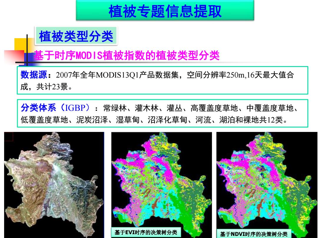
植被专题信息提取 植被类型分类 基于时序MODIS植被指数的植被类型分类 数据源:2007年全年MODIS13Q1产品数据集,空间分辨率250m,16天最大值合 成,共计23景。 分类体系(IGBP): 常绿林、灌木林、灌丛、高覆盖度草地、中覆盖度草地、 低覆盖度草地、泥炭沼泽、湿草甸、沼泽化草甸、河流、湖泊和裸地共12类。 基于EVI时序的决策树分类 基于NDVI时序的决策树分类
植被类型分类 基于时序MODIS植被指数的植被类型分类 数据源:2007年全年MODIS13Q1产品数据集,空间分辨率250m,16天最大值合 成,共计23景。 分类体系(IGBP):常绿林、灌木林、灌丛、高覆盖度草地、中覆盖度草地、 低覆盖度草地、泥炭沼泽、湿草甸、沼泽化草甸、河流、湖泊和裸地共12类。 基于EVI时序的决策树分类 基于NDVI时序的决策树分类 植被专题信息提取
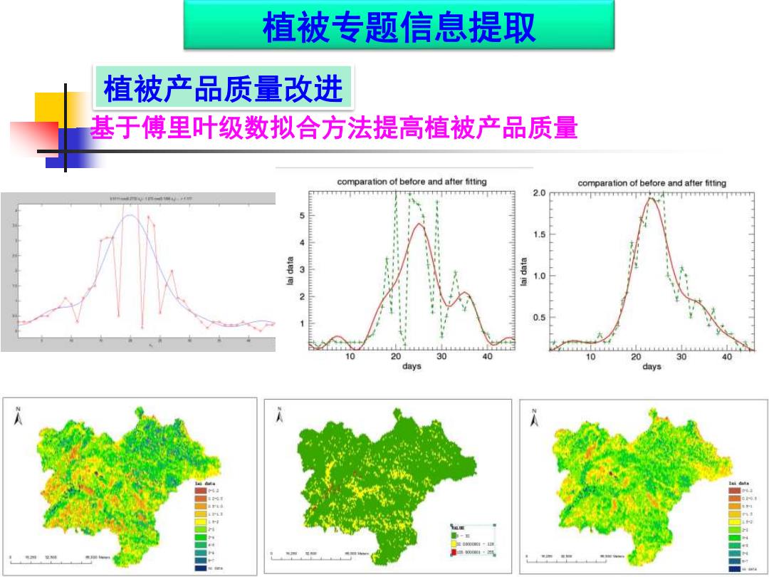
植被专题信息提取 植被产品质量改进 基于傅里叶级数拟合方法提高植被产品质量 comparation of before and after fitting comparation of before and after fitting 2.0 5 1.5 eiep e 7风 1.0 0.5 10 20 30 40 10 20 30 40 days days L
植被产品质量改进 基于傅里叶级数拟合方法提高植被产品质量 植被专题信息提取
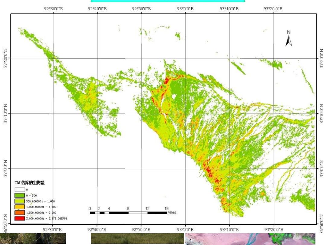
9230'0"E 9240'0"E 9250'0"E 930'0°E 93°10'0"E 9320'0"E 4·.16K0 TM估算的生物量 10 0500 500.0000001-1.000 1000.000001-1,500 0 8 12 16 1,500.000001-2,900 Miles 11·0-08099 2,000.000001-Z,78.0458 9230'0°E 9240'0E 9250'0E 930'0"E 93°100"E 9320'0E
植被参数反演 统计方法 基于遥感植被指数的地表生物量反演(估算) 外测数据 遥感数据 空间分析 归一化 数据值 适用的估算模型 抽样选取样本 生物量精度 评价 不同遥感数据生物 量估算结果图 尺度转换 生物量时空变化 特征图

植被遥感参数反演 遥感物理模型方法 基于ACRM模型和查找表算法的植被叶面积指数反演 Materails and Lnd大TM Result Data processing Unit Range or LIT product Parameters Sym bol fixed d LAI mapping value Price information (Ficld rescarch) data o1r6g有 (6S+MOOTRAN) Sun zenith angle (°) 8 20.72 Model The Au/ferra MODIS Surface 格/6dete View zenith angle (°) 6 4 act6T国 LAI Relative azimuth angle (°) 218.24 comparison Angstrom turbidity coefficient B 0.12 Retrieval scheme The mean value of retrievod LAl 5 ensitive ana小s of major model input parameters Input parameters of ACRM LAI 0-9 0.1 Leaf area index Retrieved LAl LAlg 0.05 LAI of ground level ACRM ridiative Mean leaf angle of Merit function the elliptical LAD 57.3 Hot spot parameter 0.5/LAI 4 Set up LUT Markov clumping parameter S 0.4-1.0 0.2 0.05 Weight of the first basis function S 0.05-0.5 and 0.02 Claification Look-up table Look-up table hased cn for reed dense foe reed spurse tatisic NDV司 细 销 Leaf mesophyll structure N 1.0-2.4 0.2 Chlorophyll a+b content μg 30-90 Leaf equivalent water thickness cm-2 10 cm Cw 0.015 Dry matter content 40-110 10 Brown pigment gm2 Cup 0.4
植被遥感参数反演 遥感物理模型方法 基于ACRM模型和查找表算法的植被叶面积指数反演 Parameters Unit s Sym bol Range or fixed value dx Sun zenith angle (°) s 20.72 View zenith angle Relative azimuth angle Angstrom turbidity coefficient (°) (°) v raz β 4 218.24 0.12 Leaf area index LAI of ground level LAI LAIg 0-9 0.05 0.1 Mean leaf angle of the elliptical LAD Hot spot parameter Markov clumping parameter (°) l SL Sz 57.3 0.5/LAI 0.4-1.0 0.2 Weight of the first basis function S1 0.05-0.5 0.05 and 0.02 Leaf mesophyll structure Chlorophyll a+b content Leaf equivalent water thickness Dry matter content Brown pigment g cm-2 cm g m-2 N Cab CW Cm Cbp 1.0-2.4 30-90 0.015 40-110 0.4 0.2 10 10
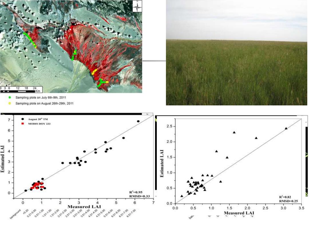
121824 ■Km Sampling plots on July 6th-9th,2011 Sampling plots on August 26th-29th 2011 Agut20”TM ● MODIS DOV 233 2.5 6 5 2.0 4- IVI pajewns3 1.5 1.0 0.5 R-0.95 RMSD-0.33 R2-0.82 0 2 3 4 5 6 0.0 RMSD-0.25 Measured LAI 05140 30 2513 354a 0.0 0.5 1.0 1.5 2.0 2.5 3.0 3.5 021050 151200 201250 451500 65t600 650-700 601 651.700 Measured LAI
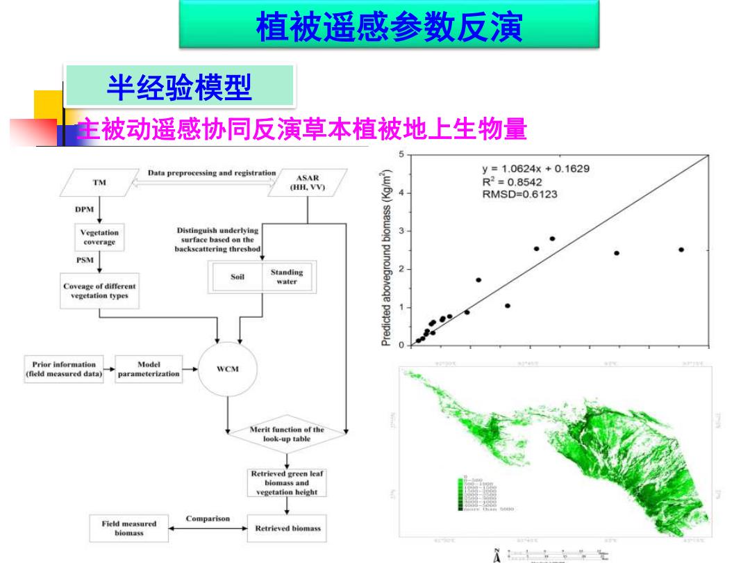
植被遥感参数反演 半经验模型 主被动遥感协同反演草本植被地上生物量 Data preprocessing and registration y=1.0624x+0.1629 ASAR T (HH.VV) R2=0.8542 RMSD=0.6123 DPM Vegetation Distinguish underlying 3 coverage surface based on the backscattering threshod PSM Standing 2 water Coveage of differen vegetation types Prior information Model WCM (fleld measured data) parameterization Merit function of the look-up table Retrieved green leaf biomass维nd vegetation height Field measured Comparison Retrieved hiomass biomass 士,,生
植被遥感参数反演 半经验模型 主被动遥感协同反演草本植被地上生物量

植被遥感应用 口服务信息 生态环境综合评价系统 产品缩略图: 园制坑数州岸国 问3 产品名称: landuse 生态环境综合评价系统 产品类型: MapServer Ecological Environment Comprehensive Evaluation System 产品时间: 2013年6月20日 所混地区: 中国四川省若尔盖地区 用户名:wny 密码: 年布中年 描述信息: 土地利用图 登陆 确定 多的 w
植被遥感应用 生态环境综合评价系统
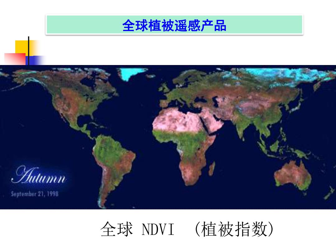
全球植被遥感产品 58时ember21,1998 全球DVI (植被指数)
全球 NDVI (植被指数) 全球植被遥感产品